An integrated global map of biodiversity, carbon storage, and other nature services to support decision making on national, regional, and global targets
Motivation
The world is losing biodiversity, carbon stocks, and ecosystem services at unprecedented rates. On current trends the Aichi targets for biodiversity and the 2020 biodiversity targets contained in the Sustainable Development Goals (SDGs) will be missed by a wide margin. A failure to conserve habitats and halt species extinction would have knock-on effects on the objectives of the UN Framework Convention on Climate Change (UNFCCC), since significant greenhouse gas emissions result from the destruction and degradation of forests and other high-carbon ecosystems. Such ecosystems can, if left intact or restored, absorb a significant share of greenhouse gas emissions from the atmosphere. If poorly managed, such mitigation strategies might further accelerate the loss of natural habitats and species.
China will convene the 15th Conference of the Parties of the Convention on Biological Diversity (CBD) in 2021 to agree on the next Strategic Plan for the CBD, including 2030 targets for maintaining biodiversity as well as a longer-term vision for nature. Thereafter, countries will convene under the UN Framework Convention for Climate Change (UNFCCC) to review the level of ambition of Nationally-Determined Contributions (NDCs) and to submit their long-term Low-Emission Development Strategies (Art. 4.19 Paris Agreement) that lay out how countries will achieve the long-term objective of the convention, which requires zero net emissions of greenhouse gases.
Meeting the ambitious objectives of the UNFCCC and the CBD requires clarity on how ambitious targets can be translated into national policies. In the case of biodiversity and other ecosystem services, the world lacks fully integrated, science-based analyses to translate politically agreed levels of ambition into operational targets at local, national, regional, or global levels. Since habitats, biodiversity, and ecosystem services are highly location specific, high-resolution maps of significant terrestrial biodiversity and carbon storage as well as corresponding restoration potential using the best available scientific data can support decision making.
Yet, today’s climate strategies – the Nationally Determined Contributions (NDCs) – do not contain actionable maps. Similarly, the vast majority of Nationally Biodiversity Strategy Action Plans (NBSAPs) under the CBD lack maps. Yet, such integrated maps are critical to support governments in translating politically agreed levels of ambition into geospatially explicit policy objectives that can be pursued and monitored using locally appropriate policy tools and data sources.
The project
To fill these gaps and to support stronger NDCs and NBSAPs, the International Institute for Applied Systems Analysis (IIASA), Instituto Internacional para Sustentabilidade (IIS), the UN Sustainable Development Solutions Network (SDSN), and the UN Environment World Conservation Monitoring Center (UNEP-WCMC) launched the Nature Map initiative. With financial support from Norway’s International Climate and Forest Initiative (NICFI), this initiative has developed new spatial data on the distribution of species, carbon stocks, and clean water. The data has been integrated using state-of-the-art multi-criteria decision analyses tools, to identify spatially where the greatest synergies exist for conservation and restoration efforts that promote Nature-Based-Solutions for climate change mitigation, biodiversity conservation and clean water. Nature Map methods are globally consistent, use the best spatial data available, and draw on local information through consultative evaluations.
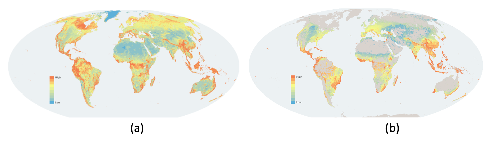
Initial Nature Map results: Areas of global significance for (a) conservation and (b) restoration of biodiversity and carbon storage
The consortium members have been working with the CBD, the UNFCCC, national governments, the scientific community, civil society, and business actors to identify the best available data and discuss the strengths and weaknesses of different methodologies for aggregating and prioritizing conservation and restoration opportunities. We have organized a series of expert consultation workshops to discuss key data and methodological issues.
A priority for Nature Map is to improve knowledge of the global distribution of species that have been poorly mapped in the past, such as plants. Thanks to our own modelling work and our partnership with Royal Botanic Gardens Kew, IUCN, Botanic Garden Conservation International and Botanical Information and Ecology Network, we were able to mobilize existing but unpublished range maps, or generate new range maps for some 200,000 plant species in total, corresponding to about 41% of all plants known to science. Nature Map constitutes the largest spatial dataset of plant species ranges. Our own modelling has also been supported by new primary observations generated through a citizen-science campaign on iNaturalist, exceeding 34,000 new submissions and generating some 2,100 new species records.
In future, satellite data on land-use change can be combined with the Nature Maps to assess how biodiversity, carbon storage, and other ecosystem services change over time and to track progress towards meeting the objectives of the CBD and the UNFCCC related to biomass carbon as well as biodiversity. They will also identify knowledge gaps that the scientific community and other partners need to fill. For this reason, the data, methods, and findings are shared openly and have been submitted to independent peer review through a highly ranked scientific journal.
Nature Map strives for maximum transparency to help stakeholders understand the strengths and weaknesses of the data and aggregation methodologies. We designed an interactive web platform for expert visualization, Nature Map Explorer, to facilitate peer-review and consultation with CBD national focal points and other interested parties. To this end, the project is making available periodic updates of the maps and the underlying base data. Throughout, we highlight gaps and weaknesses in available data.
First local applications of Nature Map have started in Argentina and Mexico to support enhanced public commitments to protect forests and biodiversity. Through our work, we have been able to push the agenda forward regarding the need for spatial planning tools in biodiversity and climate strategies, such as Nature Map, and created significant interest from other national agencies, governments, stakeholders and NGOs in integrated spatial planning tools in their decision-making.
We now focus on supporting interested countries in strengthening their national mapping and land-use planning frameworks for biodiversity and carbon – particularly with a view towards strengthening national strategies for climate (NDCs) and biodiversity (NBSAPs). In parallel we aim to strengthen the global data layers and analytical tools.
